
Aerial mapping
At Red Kite UAV, we specialise in advanced aerial photogrammetry, delivering precise 2D and 3D mapping solutions tailored for land surveying, construction, planning, and environmental analysis.
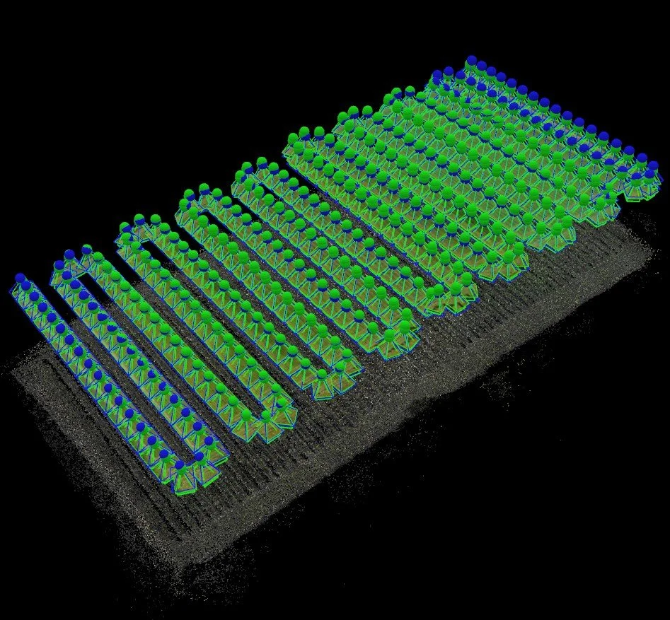
Using pre-programmed, highly accurate flight paths, our drones capture a series of overlapping, high-resolution aerial images which are then processed to generate georeferenced orthomosaic maps. These detailed 2D maps preserve spatial accuracy, enabling the extraction of X and Y coordinates, RGB colour data, and surface dimensions. Such data can be seamlessly integrated into GIS (Geographic Information Systems) and CAD (Computer-Aided Design) software for in-depth analysis, area measurements, site planning, and basic land cover classification.
For enhanced detail and dimensional analysis, we also capture oblique aerial imagery, photographing the site from angles typically between 30° and 45°. When these angled images are processed, they can be converted into highly accurate 3D meshes and models of terrain or structures. This allows for precise volumetric calculations, such as cut-and-fill assessments, and supports structural planning and progress monitoring across various stages of a project.
Further, we produce dense 3D point clouds, offering a fully navigable three-dimensional representation of the site or structure. These can be used to generate Digital Surface Models (DSM), supporting topographic mapping, slope analysis, drainage planning, and elevation profiling—ideal for both engineering and environmental applications.
To ensure optimal accuracy, we schedule flights under favourable weather conditions—avoiding strong winds and excessive shadows—as moving vegetation or fluctuating light conditions can compromise data quality.
Whether for civil engineering, asset management, or land development, our aerial mapping services provide precise, data-rich outputs that enhance planning, accuracy, and operational efficiency.


Site and Structural Inspections
At Red Kite UAV, we provide comprehensive aerial inspection services for commercial, industrial, and infrastructure sites, significantly enhancing safety, efficiency, and data accuracy while reducing the need for traditional access methods and prolonged on-site exposure.
Construction and industrial environments often pose substantial health and safety risks, particularly when inspecting areas at height, over water, or within restricted or hazardous zones. By utilising advanced Unmanned Aerial Vehicles (UAVs), we are able to conduct detailed inspections without putting personnel at risk, offering a safer, faster, and more cost-effective alternative to scaffolding, rigging, or rope access systems.
Our drones are equipped with high-resolution imaging systems and optical zoom capabilities, enabling us to capture detailed stills and video footage of critical structures including roofs, bridges, façades, towers, and riverbanks. This imagery can be reviewed in real time or delivered as a digital record, allowing stakeholders to assess structural conditions remotely from the safety of the office.
We identify and document potential defects, signs of deterioration, material fatigue, and other anomalies that may require further investigation or immediate attention. This precise visual data supports maintenance planning, risk mitigation, and regulatory compliance.
In addition to structural assessments, we also offer construction progress monitoring. By conducting regular drone flights over a site, we capture consistent aerial imagery that can be used to track development stages, verify milestones, and compare progress against project timelines. This visual documentation can be shared with stakeholders, included in reports, and integrated with BIM (Building Information Modelling) and project management platforms for enhanced oversight.
Prior to any inspection, Red Kite UAV undertakes meticulous planning and risk assessment, ensuring seamless coordination with site management, adherence to regulations, and minimal disruption to ongoing operations.
Our inspections offer:
High-definition imagery and video capture
Real-time or post-flight data access
Safe access to hazardous or restricted locations
Time-stamped progress documentation
Comparative imagery for monitoring structural change over time
Choose Red Kite UAV for a dependable, technology-driven solution that enhances your site’s safety, insight, and efficiency.
Photography and Videography
At Red Kite UAV, we deliver dynamic, high-quality aerial photography and videography services that bring a cinematic edge to your visual content — without the need for costly, large-scale production crews.
Harnessing the latest drone technology, we produce stable, sharp, and visually striking imagery using gyro-stabilised gimbals and 4K ultra-high-definition cameras. Our UAV platforms allow for fluid transitions, creative aerial manoeuvres, and unique vantage points that were once exclusive to high-budget productions.
Whether you're looking to showcase a property, promote an event, or create a compelling brand story, our team works closely with clients to capture tailored visuals that meet both creative and commercial objectives.
Our aerial imaging services include:
Marketing & Promotional Content – Bespoke aerial footage and stills for product launches, advertising campaigns, tourism initiatives, and brand storytelling, designed to engage audiences and elevate your message.
Estate Agent & Property Marketing – Captivating aerial views of residential and commercial properties, offering prospective buyers a clear and compelling overview of location, scale, and surroundings.
Commercial Property Visuals – Professional imagery to support property development, leasing, investment brochures, and planning submissions.
Event Coverage – Aerial filming for sporting events, festivals, corporate gatherings, and community functions, capturing the scale, energy, and atmosphere from an elevated perspective.
360° Aerial Panoramas – Immersive, interactive panoramic images that enhance your Google Maps presence, website content, and social media engagement—ideal for showcasing venues, campuses, or scenic locations.
Night Aerial Photography & Videography – Dramatic low-light imagery using advanced camera sensors to highlight illuminated cityscapes, architectural features, and event lighting with clarity and depth.
We approach every project with a strong focus on visual storytelling, creativity, and professionalism, ensuring that your aerial content not only looks impressive but also delivers strategic impact.
Let Red Kite UAV elevate your vision — with imagery that inspires, informs, and engages.


Utility and Asset Inspections
At Red Kite UAV, we offer specialised drone inspection and survey services for critical utility infrastructure, including wind turbines, solar (photovoltaic) installations, electrical transmission systems, pipelines, and substations. Our approach enhances safety, reduces operational costs, and delivers high-resolution data with exceptional accuracy and efficiency.
Traditional inspection methods often require expensive scaffolding, rope access, or shutdowns, placing personnel in high-risk environments. By deploying UAV technology, we remove these barriers — offering a non-intrusive, rapid, and cost-effective means of assessing asset condition and operational performance.
Our drones are equipped with high-resolution cameras and zoom lenses, capable of capturing detailed imagery and video footage from safe distances. This allows for the identification of surface defects, corrosion, misalignments, panel soiling, wear and tear, and other issues that may impact performance or safety. The enhanced clarity and volume of data collected far surpass traditional visual inspection methods.
Key benefits of our utility and asset drone inspections include:
Wind Turbine Inspections – Detecting blade cracks, lightning strikes, leading-edge erosion, and structural anomalies with precision, without halting turbine operations.
Solar Farm Surveys – Assessing photovoltaic arrays for hotspots, shading, panel damage, or debris using both visual and multispectral sensors to enhance energy output and maintenance planning.
Electrical Infrastructure Monitoring – Inspecting overhead lines, pylons, insulators, and transformers with minimal disruption, providing rapid situational awareness and supporting preventative maintenance strategies.
Pipeline and Industrial Asset Inspections – Capturing data on hard-to-reach installations such as flare stacks, cooling towers, and fluid pipelines, allowing for efficient planning and response.
Thermal Imaging (Optional) – Integrated with infrared sensors to identify overheating components, electrical faults, or compromised insulation on solar panels and substations.
All operations are conducted in full compliance with CAA and EASA guidelines, supported by thorough planning and risk assessments. Our reporting can be tailored to client requirements and delivered in standard formats compatible with asset management platforms.
Partner with Red Kite UAV for reliable, safe, and data-rich inspection solutions that empower better decisions and extend the life and performance of your utility assets.
Multispectral & Crop Analysis
At Red Kite UAV, we offer advanced multispectral drone surveys designed specifically for agricultural monitoring, environmental analysis, and vegetation health assessments. By capturing data beyond the visible spectrum, we empower land managers, farmers, agronomists, and environmental consultants with actionable insights to improve productivity, sustainability, and land stewardship.
Using state-of-the-art UAVs equipped with multispectral sensors, we collect reflectance data across multiple bands, including near-infrared (NIR), red edge, and green wavelengths. This data is used to calculate indices such as the Normalised Difference Vegetation Index (NDVI), GNDVI, and NDRE, which reveal detailed information about plant health, stress levels, water distribution, and chlorophyll content—invisible to the naked eye.
Key applications and benefits of our multispectral and crop analysis services include:
Precision Agriculture – Identify underperforming zones, detect disease or pest infestations early, assess irrigation effectiveness, and inform variable rate applications of fertilisers and pesticides to maximise yield and minimise input waste.
Crop Health Monitoring – Track crop development through the growing season, compare historical data to monitor trends, and take timely corrective action based on data-driven insights.
Environmental and Land Use Surveys – Support conservation efforts and land-use planning by evaluating plant biodiversity, habitat conditions, reforestation progress, and the impact of land management practices.
Soil and Drainage Analysis – Detect areas of waterlogging or drought stress, assess soil compaction and drainage performance, and improve overall field health through more informed land preparation.
Thermal & RGB Integration – For holistic analysis, we can integrate thermal and RGB imagery with multispectral data, offering a complete view of crop conditions and environmental dynamics.
Data collected is processed into high-resolution multispectral maps, compatible with leading agricultural and GIS software platforms. These outputs enable detailed field zoning, comparative analysis, and targeted interventions, ultimately increasing efficiency and sustainability in land management.
All surveys are carried out by qualified pilots under strict operational protocols, ensuring the highest levels of accuracy, compliance, and safety.
Choose Red Kite UAV for cutting-edge aerial intelligence that cultivates healthier crops, smarter farming, and more resilient landscapes.


Roof Inspections
Welcome to the forefront of innovation in roof inspections! Our platform is dedicated to showcasing the myriad uses and unparalleled benefits of utilising Unmanned Aerial Vehicles (UAVs) for inspecting roofs of all types. Say goodbye to outdated, time-consuming methods and embrace the efficiency and precision of UAV technology.
Efficiency Redefined: With UAVs, inspecting roofs becomes faster and more efficient than ever before. Gone are the days of manual inspections that require extensive time and labour. UAVs streamline the process, delivering comprehensive assessments in a fraction of the time.
Safety First: Traditional roof inspections often put personnel at risk, requiring them to navigate hazardous environments. UAVs eliminate this risk by providing a safe, remote alternative. Operators can assess roofs from a distance, ensuring the safety of both personnel and property.
Unmatched Accuracy: UAVs are equipped with advanced imaging technology, capturing high-resolution photos and videos with unmatched clarity. This level of detail allows for precise assessments, identifying even the smallest defects or anomalies that may escape the naked eye.
Cost-Effective Solutions: By minimising labour costs and reducing the need for expensive equipment, UAVs offer a cost-effective solution for roof inspections. Businesses can optimise their resources while maximising the quality of their assessments, resulting in significant savings over time.
Versatility Across Industries: Whether you're in construction, real estate, insurance, property management, or Home Owner, UAVs offer versatile solutions tailored to your specific needs. From residential homes to commercial properties, UAVs adapt seamlessly to various environments, providing invaluable insights every step of the way.
Environmental Sustainability: Embracing UAV technology isn't just about efficiency—it's also about sustainability. By reducing the need for physical inspections and minimising carbon emissions, UAVs contribute to a greener, more eco-friendly approach to roof maintenance and assessment.
Why Choose Us?
Expertise and Reliability: We specialise in leveraging UAV technology to deliver exceptional results. Trust us to provide reliable, accurate assessments that exceed your expectations every time.
Customised Solutions: We understand that every project is unique. That's why we offer tailored solutions designed to meet your specific requirements. Whether you need a one-time inspection or ongoing monitoring, we've got you covered.
Commitment to Excellence: At our core, we're committed to excellence in everything we do. From our cutting-edge technology to our unparalleled customer service, we strive for perfection in every aspect of our operations.
Join us on the forefront of innovation and discover the limitless potential of UAVs for roof inspections. Contact us today to learn more about our services and see how we can transform the way you approach roof maintenance and assessment. Let's elevate your inspections to new heights together!

“Aerial photography is not just a tool of observation —
it’s a revolution in perspective.”
William Garnett,
Pioneering aerial photographer and professor of landscape architecture